 |
 |

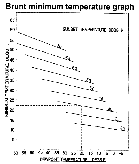
Use the above graph to help roughly predict the minimum temperatures during a coldsnap. You may either print this whole page out as an reference, or you may click on the graph above and print it out separately.
The dewpoint can be used in conjunction with air temperatures when taken at sunset to estimate the minimum temperature that will be reached during a coldsnap. As an example, if at sunset, the dewpoint is 20 degrees and the air temperature is 40 degrees, draw a line on the chart above from the 20-degree dewpoint vertically to the sunset temperature curve at 40 degrees. Then draw a horizontal line from the 40-degree curve to the left margin of the chart to come up with a minimum temperature of 22 degrees fahrenheit.
Note: This technique was designed to be used under a stable air mass of uniform moisture. Significant errors are possible if used during freezes in which the dewpoints continue to fall throughout the night.
Definitions: The dewpoint is the temperature at which the water vapor in the air condenses to form a wet film on grassy lawns, car rooftops and tree leaves. The dewpoint is equal to or less than air temperature. Dewpoint has a significant effect on the amount of heat that can be lost during coldsnaps, so knowing it can give growers a rough estimate of minimum temperatures. Once the dewpoint is reached during a frost, the heat released as water vapor condenses and slows the rate of temperature drop.
Home |
Health |
Organizations |
Information | Weather
| Recipes | Gift Fruit
| FCOJ | Growers |
Products
International
| Miscellaneous | Other
| Music | Environment
| Cal-Az-Tex |
News | Advertise |
Linking |
Comments